When the Signal
Is the Mission
A practical field guide to resilient communications for remote conservation — LoRa, radio, satcom, mesh, Starlink, and the art of staying connected when there is no tower in sight
Remote conservation work has a simple communications problem: the places that most need monitoring are often the places with the least infrastructure. Rangers patrol valleys where mobile coverage disappears. Camera traps sit beyond Wi‑Fi. Research teams work from temporary camps. Anti-poaching teams need voice comms now, not when a cloud dashboard eventually syncs. Communities near protected areas need fast warnings when elephants, lions, buffalo or wildfire move toward people.
The answer is not one magic network. It is a layered communications stack. Voice radio keeps teams safe during patrols. LoRa and Meshtastic move small messages and location packets when there is no cell service. Satellite messengers and satellite phones provide an emergency backstop. Point-to-point Wi‑Fi and microwave links connect outposts. Cellular routers and directional antennas exploit weak coverage at the edge of the network. Starlink and other low-Earth-orbit satellite internet systems can turn a remote camp into an online operations centre. Field platforms such as EarthRanger or SMART then turn all those signals into an operational picture.
This article is written for conservation teams, field operations managers, wildlife researchers, reserve owners, ranger units and students building technology for field deployment. It explains what each communication layer does, where it works, where it fails, and how to combine the pieces into a practical system.
Source note: This post was researched from official Meshtastic, LoRa Alliance, The Things Network, Garmin, Iridium, Starlink, Ubiquiti, EarthRanger, African Parks, ICASA, GSMA and related conservation-technology sources. Source links are included throughout and listed again at the end.
The Big Idea: Build for Failure
A good field communications plan assumes things will break. Batteries die. Repeaters lose power. Vehicles park behind ridges. Rain degrades links. Solar panels get dusty. Antennas are mounted too low. Mobile towers go down. A satellite terminal cannot see the sky. A phone app works at base but not under tree cover. A ranger forgets to charge the device that was supposed to save the day.
That is why resilient field comms should be designed like aviation or emergency response: layered, simple, rehearsed and redundant. The goal is not to create the fanciest network. The goal is to answer four questions reliably:
Where is the team? Location and status.
Can the team call for help? Distress, injury, breakdown, security incident.
Can the control room coordinate a response? Voice, dispatch, map, incident log.
Can data get out eventually? Patrol reports, camera-trap alerts, collar data, sensor data, photos and field notes.
Different technologies answer different parts of that problem. Radio is still king for immediate group voice. LoRa is excellent for tiny low-power packets. Wi‑Fi bridges are good for fixed links. Cellular is cheap where coverage exists. Starlink is powerful for remote internet. Sat messengers are good for last-resort SOS and check-ins. None of them is enough alone.
The Communications Stack at a Glance
| Layer | Best for | Typical payload | Strength | Weakness |
|---|---|---|---|---|
| VHF/UHF radio | Immediate patrol voice, dispatch, safety. | Voice, short text, GPS on digital systems. | Fast, simple, shared situational awareness. | Needs spectrum planning, repeaters and radio discipline. |
| LoRa / Meshtastic | Off-grid text, location beacons, simple team tracking, low-power sensors. | Small messages, GPS position, telemetry. | Cheap, low power, peer-to-peer, works without cell towers. | Low bandwidth, terrain-sensitive, not for voice or images. |
| LoRaWAN | Structured sensor networks across farms, reserves and research sites. | Telemetry from collars, gates, tanks, weather stations, traps. | Long range, low power, private/public network options. | Designed for IoT data, not team chat. |
| Satellite messenger | Emergency SOS, two-way text, check-ins for isolated teams. | Text, location, SOS, sometimes weather/photos/voice snippets. | Works far beyond mobile networks. | Subscription cost, slow messages, sky view needed. |
| Satellite phone / PTT | Remote command, voice call, emergency coordination. | Voice, SMS, low-rate data. | Human voice when nothing else works. | Expensive, operationally fragile if not charged/tested. |
| Starlink / LEO satellite internet | Remote base camps, mobile command posts, uploads, dashboards, video calls. | Broadband internet. | High bandwidth in remote areas. | Needs power, clear sky, regulatory approval and subscription. |
| Point-to-point Wi‑Fi | Fixed links between lodges, towers, gates, outposts and offices. | IP data, cameras, dashboards, VoIP, file sync. | High bandwidth and low recurring cost once installed. | Needs line of sight, towers, alignment and lightning protection. |
| Long-range cellular | Using weak edge coverage with proper routers, SIMs and antennas. | Normal internet, alerts, apps, photos, reports. | Cheap and familiar where coverage exists. | Coverage is patchy; boosters/repeaters are regulated. |
| Offline phone apps / P2P Wi‑Fi | Nearby device-to-device messages, local forms, data handoff. | Messages, forms, files, sync bundles. | Useful when the internet is down but phones are nearby. | Short range unless combined with other radios or access points. |
1. VHF/UHF Radio: Still the Backbone of Field Safety
For ranger teams, two-way radio remains the most important layer. It is immediate, shared and operationally simple. When a vehicle breaks down, a rhino security unit changes route, a fire line shifts, or a dangerous animal is near a walking team, push-to-talk voice is faster than typing into an app.
Most reserves use some combination of VHF, UHF, analogue repeaters, digital mobile radio (DMR), trunked radio, vehicle radios and handheld radios. The details depend on terrain, licensing, budget and security requirements. In open savanna, VHF often travels well. Around buildings, vehicles and broken terrain, UHF can be useful. Digital systems can add cleaner audio, GPS tracking, emergency buttons, man-down alerts, text messaging and dispatch consoles.
The modern pattern is radio plus map. A digital radio system can show ranger positions in a control room, while an operations platform such as EarthRanger or SMART stores incidents, tracks patrols and integrates collar/sensor feeds. EarthRanger describes its role as bringing field data, wildlife, teams and technology together in real time, and African Parks describes using EarthRanger as a real-time operational tool for ranger patrols, wildlife monitoring and human-wildlife conflict response.
Radio is not glamorous, but it is often the difference between a good technology deployment and a dangerous one. If a new drone, AI camera, LoRa tracker or satellite terminal does not improve the radio command picture, it may not improve field safety.
Good field practice
- Give every team a simple call sign.
- Keep a daily radio check schedule.
Use standard words for emergency, medical, vehicle, wildlife and security incidents.
Do not share sensitive wildlife locations on open or poorly controlled channels.
Mount repeaters high, power them with solar/battery backup and protect them from lightning.
Train new rangers on radio discipline before they need it in an emergency.
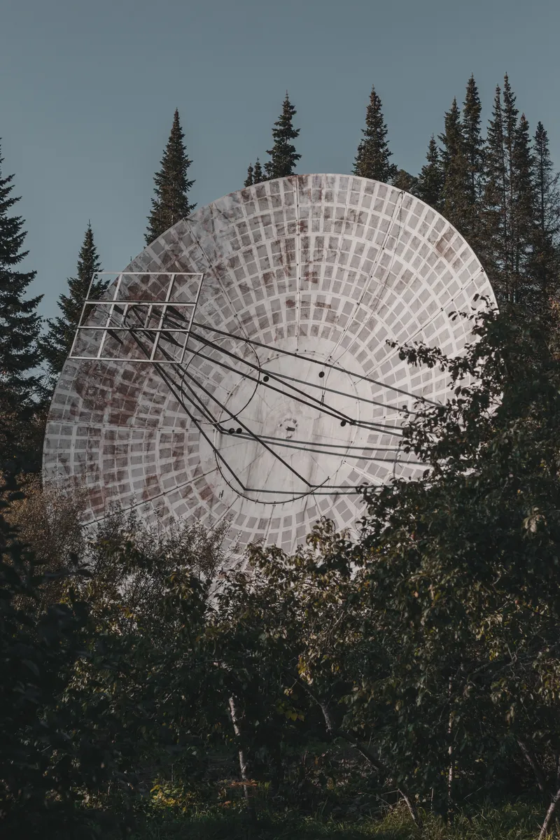
2. LoRa and LoRaWAN: Tiny Packets Over Long Distances
LoRa is a radio modulation designed for low-power, long-range communication. LoRaWAN is the network protocol built on top of LoRa for structured sensor networks. The Things Network explains the distinction clearly: LoRa is the physical radio technique, while LoRaWAN defines how devices communicate, how messages are formatted and how network servers handle devices.
In conservation, LoRa-style systems are useful when you need small packets, not broadband. Think water-tank levels, fence alarms, gate sensors, weather stations, acoustic sensor health checks, trail-counter data, camera-trap status messages, GPS pings from vehicles, or low-frequency collar telemetry. LoRa is not for sending images, voice or video.
The LoRa Alliance describes LoRaWAN as a low-power wide-area technology for affordable sensor connectivity, including private, public and hybrid network options. The Things Network notes that LoRaWAN is suited to small payloads over long distances, often more than 10 km in rural areas under good conditions, while end devices can run for years because they transmit very little data.
Where LoRa shines
Low power: small solar or battery-powered devices can last a long time.
Long distance: good range when antennas are high and terrain is kind.
Low cost: devices and gateways can be much cheaper than cellular or satellite hardware.
Local ownership: a reserve can run a private network without waiting for a mobile operator.
Where LoRa fails
- It cannot move much data.
- Dense bush, ridges and valleys can block links.
- Duty-cycle and local spectrum rules matter.
- Network planning is still engineering, not magic.
3. Meshtastic: LoRa for Off-Grid Team Messaging
Meshtastic is an open-source project that uses inexpensive LoRa radios as a long-range, off-grid communication platform for places without reliable communications infrastructure. Instead of connecting through a tower, devices can relay messages through other devices in a mesh. A phone connects to a small radio over Bluetooth; the radio sends short messages and GPS position packets over LoRa.
Meshtastic is attractive for wildlife teams because it is cheap, hackable and independent. A research team can place router nodes on hills, vehicles or camp buildings. Rangers can carry small nodes. Volunteers can send text check-ins without cell coverage. A field technician can see rough positions of nearby team members. A base-station node can bridge messages to MQTT or an operations system when internet is available.
It is important not to oversell it. Meshtastic is not a replacement for licensed mission-critical voice radio. It does not give you broadband. It is not guaranteed emergency infrastructure. The mesh must be planned, tested and maintained. Antenna height matters more than marketing range claims. A node in a backpack under tree cover is not the same as a node on a hill mast.
Security note
Meshtastic supports AES256-CTR encryption for message payloads, but its documentation warns that the default primary channel uses a known key and should be changed for real privacy. Packet headers are also not encrypted because nodes need to relay traffic. Treat Meshtastic as useful operational messaging, not as a covert anti-poaching command system unless it has been configured and threat-modelled carefully.
Best conservation uses
- Volunteer groups spread across a reserve.
Research assistants working within a known valley or transect network.
Backup check-ins for hiking, snare patrols or camera-trap servicing.
- Low-cost vehicle or team beacons inside a private mesh.
- Education projects showing how radio mesh networks work.
Bad uses
- Sending photos, videos or large files.
- Replacing emergency radio for armed or high-risk patrols.
- Assuming encryption is safe without changing default keys.
Using imported radios without checking local frequency plans and type approval.
4. Satellite Messengers: The Personal Safety Backstop
A satellite messenger is a small device for two-way text, location sharing and SOS. It is not a replacement for a radio network, but it is very useful when one person or one team is beyond all terrestrial coverage. Garmin’s inReach products, for example, advertise two-way text messaging and SOS functionality with a satellite subscription, while Iridium positions its satellite network for mission-essential communications across the planet.
In the field, the best use is boring and disciplined: each remote team sends a scheduled check-in, the control room knows when to escalate, and the device is kept charged, labelled and paired to the correct phone. An SOS button is not a plan by itself. The plan is who receives the alert, who can respond, which helicopter/vehicle/medical contact is called, and what happens if the satellite message is delayed.
Best uses
Solo researchers, remote camera-trap technicians or anti-poaching observation teams.
- Emergency SOS in areas with no radio or cell coverage.
- Simple daily check-ins from remote camps.
- Backup communications for expedition vehicles.
Limitations
- Messages are slow compared with cellular chat.
- Subscriptions must be active and paid.
- Tree cover, cliffs, vehicles and buildings can block sky view.
Staff must know how to trigger SOS and how to cancel false alarms.
5. Satellite Phones and Push-to-Talk: Voice Beyond the Tower Map
Satellite phones and satellite push-to-talk systems are used when a team needs voice communication far outside terrestrial coverage. They are more expensive than handheld radios and satellite messengers, but in remote marine work, desert surveys, transfrontier patrols, mountain deployments or disaster response they can be worth the cost.
The main decision is whether you need occasional emergency voice calls or structured operational group comms. A single satphone at base camp is useful for escalation. Satellite push-to-talk can support distributed teams, but cost, training, device management and operating procedures become more serious.
Operational advice
Keep numbers and procedures printed in the vehicle and in the control room.
- Test calls monthly, not only during emergencies.
- Carry a spare battery or power bank.
- Store devices where staff can actually access them.
Do not assume satellite voice is private or immune to disruption; use it for safety and coordination, not sensitive tactical details unless properly secured.
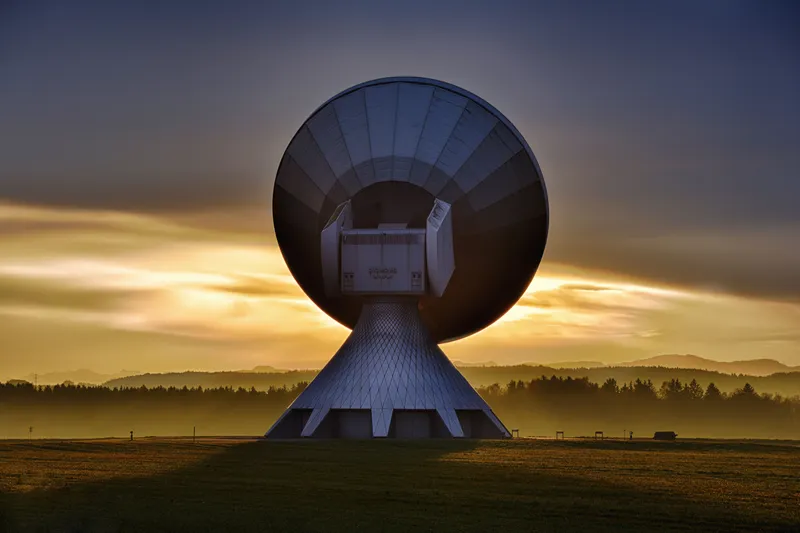
- Starlink and LEO Satellite Internet: Broadband for Camps and Command
Posts
Low-Earth-orbit satellite internet has changed what a remote field camp can do. A site that once had only VHF radio can now upload camera-trap batches, sync SMART or EarthRanger data, run video calls, download maps, send drone imagery, update software and back up field photos.
Starlink is the most visible example. SpaceX’s Direct to Cell materials describe a separate satellite-to-mobile path for ordinary LTE phones through operator partnerships, while standard Starlink terminals provide broadband through a dish/terminal. These are different products. For conservation operations today, the practical use case is usually a Starlink terminal at a lodge, reserve office, research camp, mobile command vehicle or field ranger base.
The catch is power, regulation and governance. A terminal needs reliable electricity and clear sky. It needs a legal service plan in the country of operation. It can become a single point of failure if every dashboard, camera, patrol report and emergency workflow depends on it. It can also create cyber-security and staff-management issues if the field internet becomes an unmanaged open Wi‑Fi network.
A good Starlink deployment looks like this
Solar/battery or generator backup sized for the terminal, router and key devices.
Router with firewall rules, separate staff/ops/guest networks and bandwidth controls.
- Offline workflow for when the link drops.
- Mounting that survives wind, dust, animals and curious humans.
- Documented legal approval and billing ownership.
Southern Africa note
Starlink availability in southern Africa changes by country and depends on licensing. Reuters reported Zimbabwe approval in 2024 and Lesotho licensing in 2025, while South Africa has faced licensing obstacles. For a South African reserve or NGO, do not assume a kit purchased elsewhere is lawful to import, resell or operate. Check the official availability map, the local communications regulator and your organisation’s compliance requirements before deployment.
7. Point-to-Point Wi‑Fi and Microwave: The Fixed-Link Workhorse
Point-to-point wireless links are one of the most useful underappreciated tools in conservation tech. If you can see from one hill, lodge or tower to another, you may be able to move high-speed IP data across kilometres without trenching fibre or relying on a mobile operator. Vendors such as Ubiquiti publish point-to-point and long-range Wi‑Fi configuration guides and devices with directional antennas for fixed wireless links.
This is not the same as normal campsite Wi‑Fi. Long-range Wi‑Fi uses directional antennas aimed at each other. It needs line of sight, careful alignment, clean power, correct channels, weatherproofing and lightning protection. Done well, it can connect a gate camera, ranger post, rhino boma, remote office, lodge, airstrip, hill repeater or Starlink backhaul to the main network.
Best uses
- Linking reserve headquarters to a remote gate or tower.
- Backhauling camera feeds from a waterhole or fence line.
- Connecting a hilltop radio repeater site to the internet.
Sharing Starlink or fibre from one site to nearby operational buildings.
Connecting LoRaWAN gateways or EarthRanger hardware integrations.
Failure modes
- No true line of sight.
- Antennas mounted too low.
- Wrong frequency choice in a noisy area.
- Lightning damage.
- Poor grounding.
- Water ingress.
- No one knows the admin password two years later.
8. Long-Range Cellular: Use the Edge of the Network Properly
In many reserves, mobile coverage is not absent; it is just weak, patchy or high on ridgelines. A normal phone may fail, while an industrial LTE/5G router with an outdoor directional MIMO antenna, good cable and the right SIM can work. This is often the cheapest useful data link when coverage exists.
Cellular is excellent for camera alerts, staff messaging, app sync, remote sensors, telemetry gateways and visitor operations. It is also familiar: everyone understands SIM cards and data bundles. But it can collapse during power outages, storms, tourist peaks or tower maintenance. It also depends on the operator’s coverage, bands, fair-use policy and roaming rules.
Practical advice
Survey signal using multiple networks, not one phone on one day.
- Test at height: roof, mast, koppie, water tower, repeater site.
- Use directional outdoor antennas for fixed sites.
- Use dual-SIM routers where possible.
Do not use illegal boosters or repeaters; they can interfere with licensed networks.
- Log uptime and data use before declaring the link reliable.
For IoT, LTE‑M and NB‑IoT are also important. GSMA describes LTE‑M and NB‑IoT as low-power wide-area cellular technologies designed for IoT devices with lower complexity, extended coverage and long battery life. They are not everywhere, and they require operator support, but they matter for future conservation telemetry where licensed-spectrum reliability is preferred over unlicensed LoRa.
9. Offline Phone Apps and Peer-to-Peer Wi‑Fi
Sometimes the problem is not long-distance communication. It is local data movement. A ranger has forms on a phone. A camera-trap team has photos on a laptop. A researcher has species notes. The base camp internet is down, but the team is physically together.
Peer-to-peer tools can help. Briar, for example, describes itself as a secure peer-to-peer messaging app that can connect via Bluetooth, Wi‑Fi or Tor and can sync without central servers. In conservation, the same principle matters beyond chat: field apps should be able to store data offline, sync locally, export files and recover from intermittent connectivity.
The range is usually short. Phone-to-phone Bluetooth or Wi‑Fi is not a reserve-wide radio network. But for camps, vehicles, training groups, data handovers, emergency notebooks and offline-first patrol systems, local sync is valuable.
Good uses
- Offline patrol forms that sync when a team returns to base.
- Local sharing of maps, SOPs, incident forms and species guides.
- Short-range peer messaging during internet outages.
Bulk transfer from field laptop to office server without cloud connectivity.
10. The Operations Layer: Turning Signals Into Decisions
Communications hardware is only useful if people know what to do with the information. A LoRa sensor that reports a broken fence, a Starlink link that syncs patrol forms, a radio GPS ping, a satellite check-in and a camera-trap alert all need to land somewhere. That somewhere may be a control room whiteboard, a WhatsApp group, a radio dispatcher, a spreadsheet, SMART, EarthRanger, QGIS, a custom database or an incident management system.
EarthRanger says it integrates field data, technology, wildlife and teams in real time, with more than 900 supported conservation sites, more than 23,000 animals tracked via GPS and more than 150 integrations. African Parks describes EarthRanger as combining ranger patrols, remote imaging and sensors into a real-time tool for anti-poaching, wildlife monitoring and human-wildlife conflict response.
The important design question is not “What network should we buy?” It is “What decision should this network help us make?” A fence alarm should create a maintenance task. A person-detection camera should create a patrol response. A ranger SOS should trigger a medical protocol. A collar breach should alert the human-wildlife conflict team. A failed gateway should create a technician ticket.
Reference Architectures
Small reserve or conservancy
| Need | Suggested layer | Notes |
|---|---|---|
| Daily patrol voice | VHF/UHF handhelds + one repeater if terrain requires it. | Start with voice safety before adding data toys. |
| Remote team check-ins | Meshtastic or satellite messenger. | Use Meshtastic where teams are within a planned mesh; satellite for true remote fallback. |
| Office internet | Cellular router, fibre, WISP or Starlink if legal/available. | Use dual-WAN if budget allows. |
| Gate or waterhole camera | Cellular camera or point-to-point Wi‑Fi. | Use Wi‑Fi bridge when fixed site has line of sight. |
| Sensor alerts | LoRaWAN gateway + sensors. | Good for tanks, gates, fences and weather. |
Large protected area
| Need | Suggested layer | Notes |
|---|---|---|
| Mission-critical patrol comms | Licensed digital radio network with repeaters, GPS and dispatch. | Design professionally; test dead zones and incident workflows. |
| Outpost connectivity | Point-to-point microwave/Wi‑Fi, cellular router or Starlink. | Use the cheapest reliable backhaul per site. |
| Ranger/personnel safety | Radio emergency button + satellite messenger for isolated teams. | Do not depend on one path. |
| Wildlife and asset tracking | GPS collars, LoRaWAN, cellular IoT, satellite IoT. | Choose based on species, terrain, update rate and battery life. |
| Operations dashboard | EarthRanger/SMART/custom GIS. | The dashboard is only useful if someone is assigned to act on alerts. |
Mobile research expedition
| Need | Suggested layer | Notes |
|---|---|---|
| Vehicle-to-vehicle | VHF/UHF mobile radios or handhelds. | Keep this simple and trained. |
| Camp internet | Starlink, cellular router or local WISP. | Power budget matters more than bandwidth claims. |
| Team text and location | Meshtastic nodes with spare batteries. | Works best when team stays in a known operating area. |
| Emergency fallback | Satellite messenger or satphone. | Test before departure. |
| Data management | Offline-first forms + local backup + delayed cloud sync. | Do not make cloud connectivity a requirement for data capture. |
Regulatory Reality: Radios Are Not Just Gadgets
Every country regulates radio spectrum. In South Africa, ICASA is the communications regulator. ICASA explains that radio equipment generally needs type approval before it may be used, supplied, sold, leased or imported, unless exempted. ICASA also states that equipment used under spectrum licences must be type approved and that radio frequency spectrum licensing follows the national frequency plan and relevant regulations.
This matters for all the technologies in this article: VHF/UHF radios, repeaters, LoRa devices, Wi‑Fi bridges, cellular routers, boosters, satellite terminals and marine radios. Some operate in licence-exempt bands but still have power, antenna, duty-cycle and type-approval constraints. Some need licences. Some are legal in one country and not in a neighbour. Some devices sold online are configured for the wrong region.
The practical rule: before deploying at scale, ask three questions. Is the device type-approved? Is the frequency legal for this use? Is the power/antenna configuration compliant? If the answer is unclear, get help from a licensed radio dealer, WISP, network engineer or regulator-facing installer.
Security, Privacy and Sensitive Wildlife Data
Conservation communications often carry sensitive information: rhino locations, patrol routes, ranger positions, informant reports, fence breaches, camera alerts, anti-poaching movements and community conflict incidents. A network that works technically can still be unsafe operationally.
Minimum rules
Do not broadcast exact rhino, pangolin, elephant-carcass or snare locations on open channels.
- Separate guest internet from operations internet.
- Change default passwords and default Meshtastic channel keys.
Keep device inventories: serial number, SIM, owner, firmware, antenna, charger, assigned user.
- Remove access when volunteers or contractors leave.
- Do not let every alert go to every WhatsApp group.
Have a clear data-retention rule for ranger tracks and sensitive incidents.
Also remember the human side. A GPS-tracked radio can improve ranger safety, but it can also feel like surveillance if introduced badly. Explain why tracking exists, who can see it, when it is used, and how it protects staff.
The Hidden Layer: Power
Most failed field communication systems are not radio failures. They are power failures. A brilliant hilltop repeater is useless if the solar panel is shaded. A Starlink terminal is useless if the inverter trips. A LoRaWAN gateway is useless if the battery dies after three cloudy days. A satellite messenger is useless in the drawer at base camp.
Design power before you design the network. Count watts. Size batteries for bad weather. Protect against lightning. Label chargers. Keep spare cables. Use low-voltage disconnects. Log outages. Give someone ownership of every remote power system.
| Technology | Power profile | Field implication |
|---|---|---|
| Handheld VHF/UHF radio | Battery powered, daily charging. | Needs charging discipline and spare batteries. |
| Radio repeater | Continuous site power. | Needs solar/battery backup and lightning protection. |
| Meshtastic node | Low power. | Can run on battery/solar if configured carefully. |
| LoRaWAN gateway | Moderate continuous power. | Needs stable power and backhaul. |
| Cellular router | Moderate continuous power. | Good for solar sites if sized properly. |
| Point-to-point Wi‑Fi | Low-to-moderate continuous power. | Often practical on solar towers. |
| Starlink | Higher continuous power. | Needs serious power planning for off-grid camps. |
How to Choose: A Simple Decision Framework
Start with the job, not the gadget.
| Question | If yes | Likely technology |
|---|---|---|
| Do people need immediate group voice? | Safety or patrol coordination depends on it. | VHF/UHF radio, digital radio, repeaters. |
| Do you only need tiny messages or GPS pings? | Low data, low power, low cost. | LoRa, Meshtastic, LoRaWAN. |
| Is there weak but usable mobile coverage? | Coverage improves at height or with an antenna. | Industrial cellular router, directional antenna, dual SIM. |
| Can two fixed points see each other? | You need high-bandwidth site-to-site data. | Point-to-point Wi‑Fi or microwave. |
| Do you need broadband far from infrastructure? | Camp, command vehicle or office needs real internet. | Starlink or other satellite internet where legal. |
| Could a person be alone beyond all coverage? | Emergency rescue path is required. | Satellite messenger or satphone. |
| Do devices need to sync locally without internet? | Teams are physically near each other. | Offline-first apps, peer-to-peer Wi‑Fi, local servers. |
Common Mistakes
Buying hardware before mapping the problem. Walk the terrain, mark dead zones and define workflows first.
Ignoring spectrum law. Imported radios can be illegal or badly configured for local bands.
Assuming Starlink replaces radio. Broadband is not the same as mission-critical push-to-talk.
Putting LoRa nodes too low. Antenna height and line of sight are everything.
Using consumer Wi‑Fi like infrastructure. Field networks need weatherproofing, grounding and access control.
Forgetting power. Power is the network.
Not training staff. A ranger under stress should not be learning a menu system for the first time.
No escalation protocol. An SOS alert without a response plan is just a panic button.
Over-sharing sensitive locations. Communications can create poaching risk if badly governed.
Deployment Checklist
Before buying
Map patrol routes, camps, gates, ridges, valleys and high sites.
Define use cases: voice, SOS, sensor, internet, image upload, location, dashboard.
- Survey existing radio, cellular and Wi‑Fi coverage.
Check legal spectrum, type approval and satellite service availability.
- Estimate power at every fixed site.
Before deployment
- Label every device, battery, charger, SIM and antenna.
- Write a one-page SOP for each device type.
- Train users in normal and emergency use.
- Run a field test in the actual terrain.
- Create a dead-zone map.
- Change default passwords, keys and admin accounts.
After deployment
- Log outages and near misses.
- Update maps after every significant field test.
Replace failed cables and batteries before they become emergencies.
- Review incident response monthly.
- Audit who still has access to apps, dashboards and devices.
Where This Is Going
The future of conservation communications is not one network. It is convergence. Radios will carry GPS and emergency data. LoRa sensors will bridge into dashboards. Satellite-to-cell will make ordinary phones useful in more dead zones. Starlink and similar systems will make remote camps feel online. Edge AI devices will send only the important alerts instead of every image. Field platforms will increasingly combine patrol, sensor, collar, camera, acoustic and satellite data into a single map.
The best conservation teams will not be the ones with the most expensive equipment. They will be the ones with the clearest operational design: which data matters, who receives it, who acts, what happens when the link fails, and how the system protects both wildlife and people.
In the field, good communications are not about technology for its own sake. They are about trust. A ranger trusts that the radio will work. A researcher trusts that the check-in will reach base. A community member trusts that a conflict alert will be answered. A reserve manager trusts that an incident will not disappear into a dead zone. That is the real goal: fewer blind spots, faster response, safer people and better decisions for wildlife.
Sources and Further Reading
Meshtastic introduction
Meshtastic encryption documentation
- LoRa Alliance
The Things Network: What are LoRa and LoRaWAN?
Garmin inReach satellite communicators
Iridium satellite communications
Starlink Direct to Cell service note
Ubiquiti airMAX LiteBeam long-range technical specifications
Ubiquiti airMAX long-range Wi‑Fi client guide
- EarthRanger
African Parks: EarthRanger and African Parks
ICASA type approval
ICASA spectrum licensing
ICASA radio frequency spectrum regulations
GSMA LTE‑M
GSMA NB‑IoT
- Briar peer-to-peer messaging