Technology
in the Field
From GPS collars and camera traps to offline data apps, radio networks, and operations platforms — the tools that keep conservation teams working in the world's wildest places
Conservation field teams face a problem that most technology companies never think about. How do you run a real-time operations centre when the nearest mobile tower is 80 kilometres away and the nearest mains power is further? How do you collect standardised survey data when the temperature is 38°C, the sun is blinding the screen, and the baboons have just made off with your lunch? How do you track an elephant across a transboundary landscape when the collar battery dies after 18 months and the replacement costs more than a ranger’s annual salary?
These are not hypotheticals. They are the daily reality for conservation teams working in protected areas, wildlife reserves, community conservancies, and research stations across every continent. And the answer is not one magic device. It is a layered stack of tools, each solving part of the problem, wired together with field-tested workflows and a healthy tolerance for failure.
This article maps the technology stack that modern conservation runs on. It covers the hardware, the software, the connectivity layer, and the operations platforms that turn raw field data into decisions. It is written for conservation practitioners, field operations managers, reserve owners, wildlife researchers, ranger units, and students building technology for field deployment.
Source note: This post draws on EarthRanger documentation, SMART Conservation Software resources, the SERCA alliance, WILDLABS community knowledge, published peer-reviewed literature on conservation technology, LoRa Alliance specifications, GSMA connectivity data, and field reports from African Parks, Panthera, WCS, and The Field Company’s own field testing in the Cederberg Wilderness Area. Source links are listed at the end.
The Conservation Technology Stack
Think of field technology as five layers, each one depending on the layer beneath it. The layers are not rigid — a single device might span two layers — but the mental model helps when planning a deployment or diagnosing a failure.
| Layer | What It Does | Examples |
|---|---|---|
| Power | Keeps everything running | Solar panels, battery banks, vehicle alternators, power management |
| Connectivity | Moves data between devices and people | VHF/UHF radio, LoRa, Meshtastic, satellite, Starlink, cellular |
| Sensors | Collect observations from the environment | Camera traps, GPS collars, acoustic recorders, weather stations, eDNA |
| Field Software | Turns observations into structured data | EarthRanger Mobile, SMART, CyberTracker, ODK, QField |
| Operations Platform | Aggregates data, visualises operations, supports decisions | EarthRanger, SMART Desktop, ArcGIS, custom dashboards |
The layers are interdependent. A satellite collar is useless without a connectivity plan. A camera trap is useless without someone to retrieve the SD card. A field app is useless if the phone battery dies by 11:00. Successful field deployments treat the stack as a system, not a shopping list.
The Shift: From Paper to Platform
For most of conservation history, the technology in a ranger’s hands was a notebook, a pencil, and a handheld GPS if the budget allowed. Data collection was slow, error-prone, and difficult to aggregate. A poaching incident recorded in a paper logbook might reach headquarters weeks later, if at all. A wildlife sighting noted on a map might never be digitised. Camera trap images sat on SD cards in desk drawers for months before anyone reviewed them.
That world is changing fast. The drivers are not subtle: smartphones got cheap enough to deploy in the field. Satellite connectivity got reliable enough to trust. Open-source platforms like SMART and EarthRanger made operations software free for conservation use. Machine learning models like MegaDetector and SpeciesNet made it possible to process millions of camera trap images automatically. And the conservation community built the training networks and field support systems that make the technology actually usable in practice.
The shift is not complete. Many teams still rely on paper. Many protected areas still lack connectivity. Many rangers still carry consumer-grade phones that overheat and run out of battery. But the direction is clear: conservation technology is moving from something a few well-funded projects use to something every protected area can access. The SERCA alliance — the merger of SMART and EarthRanger, announced in 2025 with backing from WWF, WCS, Panthera, Frankfurt Zoological Society, ZSL, North Carolina Zoo, Wildlife Protection Solutions, and Re:wild — is perhaps the clearest signal that this is now a mainstream movement, not an edge case.
Layer 1: Power
Everything else fails without power. A field deployment plan that does not start with power is a plan to fail.
The most common power sources in conservation field work are solar panels (ranging from 5 W portable panels to multi-kilowatt fixed arrays at operations centres), sealed lead-acid or lithium-iron-phosphate batteries, and vehicle alternators for mobile teams. Solar is the default for stationary equipment — camera traps, LoRa gateways, weather stations, repeater sites — because it requires no fuel and minimal maintenance. Good solar deployments use panels sized for the worst month of the year, not the average, and battery banks sized for at least three days of zero sun.
For mobile teams, power is harder. A ranger on patrol carries at minimum a phone, a radio, and often a GPS unit or satellite messenger. Each needs charging. The standard field kit includes a power bank (20,000 mAh or larger) and a small solar panel. Vehicle-based teams can charge from the vehicle, but this introduces a dependency: the vehicle must be running and fuelled. Generator power is common at remote camps but introduces fuel logistics and maintenance overhead.
The rule of thumb: plan for every device to run for 72 hours without a recharge opportunity. Assume batteries degrade in heat. Assume solar panels get dusty. Assume someone forgets to plug something in overnight.
Layer 3: Sensors
Sensors are the eyes and ears of the conservation technology stack. They collect data from the environment that humans cannot observe directly or continuously.
Camera traps are the most widely deployed conservation sensor. Estimates suggest over 10 million camera trap images are now collected globally each year across research, monitoring, and anti-poaching programmes. Modern camera traps run for months on AA batteries, trigger on heat and motion, and store thousands of images on SD cards. Cellular camera traps add real-time transmission but at higher cost and power consumption. The bottleneck is no longer image capture — it is image processing and data management, which AI models like MegaDetector and SpeciesNet are now addressing.
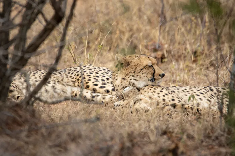
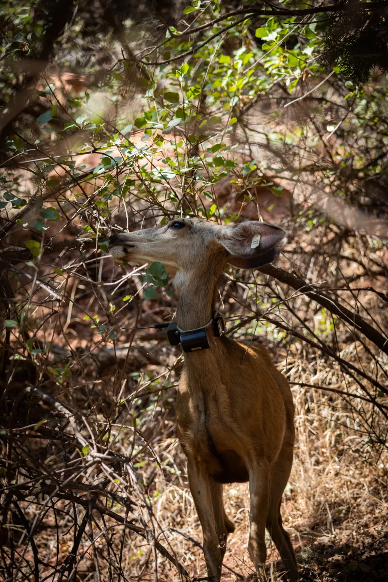
GPS collars and tags track animal movement across landscapes. As of 2026, EarthRanger alone tracks over 23,000 animals via GPS. Collars range from simple VHF-only models that require manual triangulation to satellite-linked units that transmit positions via Iridium or Argos. Costs span from a few hundred dollars for a VHF collar to several thousand for a satellite collar with accelerometer. Collar weight must stay below 3—5% of the animal’s body weight, limiting what species can be tracked.
Acoustic recorders — both terrestrial and underwater — are growing fast. BirdNET and Arbimon process terabytes of acoustic data for species identification. Passive acoustic monitoring (PAM) for marine mammals is now standard practice in offshore development impact assessments.
Environmental DNA (eDNA) samplers collect water, soil, or air samples that are later analysed in a lab to identify species present in an area. This is still more research than operations, but the cost per sample is dropping rapidly.
Layer 5: Operations Platforms
The operations platform is the top of the stack. It aggregates data from all layers below — GPS positions, camera trap detections, ranger sightings, acoustic alerts, weather data — and presents it on a map that the operations team can use to make decisions in real time.
EarthRanger is the dominant platform in this space. Free for conservation use, it is deployed at over 900 sites in more than 80 countries. It tracks wildlife, vehicles, aircraft, and personnel in real time. It generates alerts on movement patterns — immobility, speed changes, boundary crossings — and sends them via SMS, WhatsApp, or email. It integrates with over 150 third-party tools including camera traps, animal collars, vehicle trackers, IoT sensors, radios, and satellite imagery. EarthRanger Mobile (now part of the Ecoscope app) enables offline field data collection with automatic sync when connectivity is restored.
SMART (Spatial Monitoring and Reporting Tool) is the other major open-source platform. Developed by a consortium of eight conservation organisations, it is used in over 1,000 sites globally. SMART is particularly strong in law enforcement monitoring — tracking patrol routes, recording incidents, and generating reports for protected area managers. Its strength is structured data collection with configurable data models.
In 2025, EarthRanger and SMART merged under the SERCA (SMART-EarthRanger Conservation Alliance) umbrella, creating a unified technology and training organisation backed by WWF, WCS, Panthera, Frankfurt Zoological Society, ZSL, North Carolina Zoo, Wildlife Protection Solutions, and Re:wild. The goal is to close the gap between field data collection and real-time operations — and to provide the training and support that makes the technology usable for protected area teams worldwide.
Other platforms include ArcGIS (commercial, dominant in government agencies and large NGOs), QGIS (open-source desktop GIS), and Google Earth Engine (cloud-based satellite imagery analysis). Most conservation operations use a combination: EarthRanger or SMART for daily operations, ArcGIS or QGIS for spatial analysis, and Earth Engine for regional-scale remote sensing.
What Actually Happens in the Field
The gap between a technology specification sheet and its performance in the field is wide. Devices that work perfectly on a test bench at headquarters can fail in the first week of deployment. The most common failure modes are not technical — they are environmental and human.
| Failure Mode | What Happens | Mitigation |
|---|---|---|
| Heat | Phones shut down. Batteries degrade faster. Solar panels lose efficiency. | Shade devices. Use ruggedised hardware. Oversize batteries. |
| Dust and sand | Charging ports clog. Connectors corrode. Screens become unreadable. | Port covers. Wireless charging where possible. Compressed air cleaning. |
| Water | Short circuits. Fungus on optics. Paper records destroyed. | IP67 or better rating. Dry bags. Silica gel in equipment cases. |
| Connectivity loss | Data cannot sync. Alerts do not fire. Teams cannot coordinate. | Offline-first apps. Store-and-forward protocols. Redundant comms layers. |
| Battery drain | Device dies mid-patrol. GPS logging stops. Emergency comms lost. | Power banks. Solar chargers. Battery discipline training. |
| User error | Wrong data model selected. Device not charged. Antenna not extended. | Training. Checklists. Simplified interfaces. In-field support. |
The most reliable field deployments are not the ones with the most expensive equipment. They are the ones where the team has tested everything in real conditions, built redundancy into every layer, trained every user, and accepted that things will fail — and planned accordingly.
The Open-Source Advantage
Conservation technology has an unusual characteristic compared to most technology sectors: many of the most important tools are open-source and free for conservation use. This is not accidental. It is the result of deliberate decisions by conservation organisations, technology companies, and philanthropic foundations to ensure that cost is not the barrier to effective protection.
EarthRanger is free for qualifying conservation organisations. SMART is open-source and freely available. CyberTracker, one of the oldest field data collection tools (created in 1996 by Louis Liebenberg and Justin Steventon), is free. ODK (Open Data Kit) is open-source and used by conservation organisations worldwide for custom survey data collection. QField, the mobile companion to QGIS, is open-source and free. MegaDetector, the machine learning model for camera trap image processing, is open-source. PyTorch-Wildlife, Microsoft’s conservation AI framework, is open-source.
The open-source model has practical advantages for conservation. Teams can inspect the code to understand exactly what it does. They can modify it for local conditions — adding a language translation, a new data field, a custom report. They are not locked into vendor contracts or subject to licence fee increases. And the community of users and developers provides peer support that is often faster and more relevant than commercial support channels.
The trade-off is that open-source tools require local capacity to deploy and maintain. A team that downloads SMART or EarthRanger still needs someone who can configure the data model, set up the server, train the users, and troubleshoot problems. The SERCA alliance is explicitly addressing this gap with a combined training and support organisation.
The Training Gap
The most under-discussed challenge in conservation technology is not hardware or software — it is training. A 2023 survey by WILDLABS found that lack of technical capacity was cited as a barrier to technology adoption more often than cost. Protected area budgets often allocate money for equipment but not for the training, support, and maintenance that make the equipment useful.
The pattern is common: a grant buys camera traps, tablets, and GPS units. The equipment arrives. Someone installs the apps. The rangers go out. Six months later, half the tablets have cracked screens. The camera trap SD cards are full and no one has offloaded the images. The GPS units have dead batteries. The project report says “technology deployment was less successful than anticipated” and the cycle repeats with the next grant.
The organisations that avoid this trap invest in training before equipment. They bring rangers into the process early — testing devices, giving feedback on the data collection interface, flagging problems before the full deployment. They budget for replacement batteries, spare cables, screen protectors, and annual refresher training. They designate a “tech champion” on the team — someone who can answer questions, troubleshoot common problems, and serve as the bridge between the field team and the IT support.
What Is Coming
Several trends are converging that will change what field technology looks like in the next five to ten years.
AI at the edge. Machine learning models that run on the device — not in the cloud — are becoming practical for field deployment. A phone or a camera trap that can classify species, detect gunshots, or identify a vehicle without any internet connection changes what is possible in disconnected environments. PyTorch-Wildlife, Google’s SpeciesNet, and TinyML frameworks are making this accessible.
Satellite connectivity at scale. Starlink, Project Kuiper, and the next generation of low-Earth-orbit satellites are bringing broadband to remote areas. Direct-to-device satellite services (AST SpaceMobile, Starlink Direct to Cell) promise to connect standard smartphones to satellites without any additional hardware. If these services deliver, the connectivity layer of the field technology stack becomes dramatically simpler.
Unified platforms. The SERCA alliance between SMART and EarthRanger signals a consolidation trend. Instead of every protected area running its own cobbled-together stack of tools, the sector is moving toward shared, open-source platforms with professional support organisations behind them. This reduces duplication, improves interoperability, and makes training more transferable between sites.
Cheaper, better sensors. The cost of camera traps, GPS collars, acoustic recorders, and environmental sensors continues to fall. A camera trap that cost $400 in 2015 costs under $100 today with better image quality and longer battery life. eDNA analysis that cost hundreds of dollars per sample five years ago is approaching tens of dollars. As sensor costs fall, the density and coverage of monitoring networks increases.
The limiting factor, as always, will not be the technology. It will be the capacity to deploy it, maintain it, train people to use it, and act on the data it produces. Technology is a tool. The people in the field — rangers, researchers, community scouts, protected area managers — are the ones who make it work.
Deep Dives
This post is an overview. The companion articles below go deeper into specific layers of the field technology stack:
Sources
EarthRanger — Protecting Wildlife With Real-Time Data
SMART Conservation Software — Spatial Monitoring and Reporting Tool
SERCA — SMART-EarthRanger Conservation Alliance
WILDLABS — The Conservation Technology Community
- ODK — Open Data Kit
CyberTracker — Field Data Collection Software
- QField — Mobile GIS for QGIS
PyTorch-Wildlife — Conservation AI Framework
LoRa Alliance — Low Power Wide Area Network Standards
GSMA Mobile for Development — Connectivity Data